Dip a Toe in an Emerald-Colored Lake
Visitors to New Zealand walk around with jaws dropped and eyes wide at the picturesque landscapes – but the magic of what you see at the peak of the North Island’s Tongariro Crossing is the most breathtaking of all.
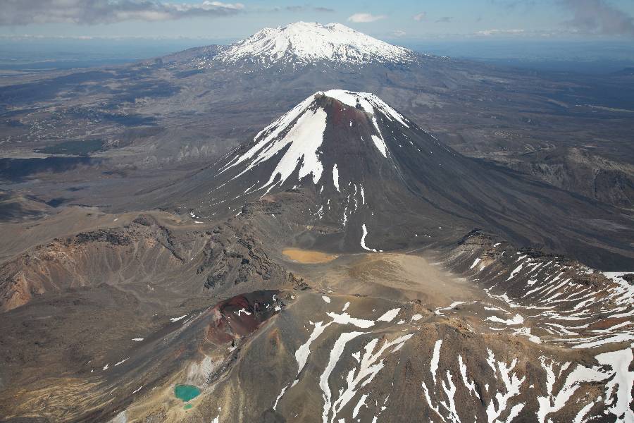
Hiking the Tongariro Crossing takes nearly 20 kilometers to enjoy all the rugged beauty of New Zealand’s oldest national park. It’s a dual World Heritage Area, honored for its three active volcanoes and Maori cultural significance. You’ll see evidence of recent lava flows, ribbons of steam from geothermal energy venting from the mountainside and striking emerald green and turquoise blue lakes that are as cold as they are mesmerizing.
You must be prepared, organized and fit for this popular climb, which winds along a track that is famous for unpredictable weather. When a Kiwi calls it just a “walk,” don’t be misled. You’ll definitely find yourself out of breath more than once, but it’s worth it.

The emerald green lakes at The Tongariro Crossing. Photo RNZ
Stage Yourself for the Hike
No matter where you stay, you’ll want to get an early start for the hike. Hiking the Tongariro Crossing can take anywhere from 4.5 to 9 hours, depending on your fitness level and how long you linger at the crest to admire the views.
While the entrance to the park itself is free, you’ll need to reserve a spot on a van of one of the licensed tour companies. Even if you have your own car, there are two reasons why this makes sense. First, the government recently implemented a four-hour parking limit at the trailhead parking lot. Second, the hike is only one way. Getting a ride is much easier – without breaking the bank at around $25 NZ – and cuts down on logistics.
Any place you stay, provided it’s south of Lake Taupo, will be able to help organize your ride. There are a wide range of accommodations available in the nearby towns, which include Taupo, Turangi, the National Park Village, Whakapapa Village and Ohakune. You can choose among cheap backpackers and posh lodges, and they’re all between 20 minutes and an hour away. Of course, there are also holiday parks nearby if you want to crash in your campervan. Turangi is probably most recommended, as it has shops so you can stock up on supplies for a filling meal after the big excursion.

Whakapapa Village and Turangi are within easy reach of the Tongariro Crossing
Prepare for the Big Day
Even though there will be plenty of people walking along with you along the 19.4 kilometers, you must prepare yourself. Weather at the peak is dramatically different from what you’ll see at the trailhead, so bring many layers, a hat and even gloves during the summer months. While the walk can be completed in the winter months, from May to October, you’ll need crampons and an ice axe. During the winter, it’s not a bad idea to hire a guide who is an expert in cold-weather climbs.
Hiking the Tongariro Crossing requires sturdy hiking boots, rain gear and a cell phone. Pack plenty of water – two liters per person is the recommendation, although more is a good idea in the heat of the summer – snacks and a lunch. If you have hiking poles, bring them too. At the peak, the trail is very steep and can be quite slippery, especially on the decline.
You’ll also want to check the weather before you head out. If the winds are more than 60 km/hour, it’ll be best to postpone your trek. The three volcanos, Ngauruhoe, Ruapehu and Tongariro, are also active, although Tongariro hasn’t erupted since 1897. You can check to make sure they’re safe before you go, too.
The Tongariro volcano has not erupted for over a 100 years Photo – PhotoVolcanica
Finally, be honest with yourself. Are you fit enough? It’s a long hike, and it’s always better to turn back – provided you haven’t crossed the Red Crater – if you feel like you can’t go on. You’ll be climbing from 800 meters to 1,900 meters above sea level and down again. While parts of the trail are level and easy, other parts are covered with volcanic gravel and steep. It’s possible for some children to complete it, but it’s not a beginner hike.
Walk on Through
Once you’ve been dropped off at the Mangatepopo car park, it’s all systems go! Stop off at one of the toilets near the boardwalk, check the map and head out on the well-marked path. You’ll be feeling fairly confident until you arrive at the steepest part of the climb. It’s known as the “Devil’s Staircase” for good reason. It takes you up the Mangatepopo Saddle and over to the South Crater. From there, you’ll head to the highest point of the trail, called the Red Crater.
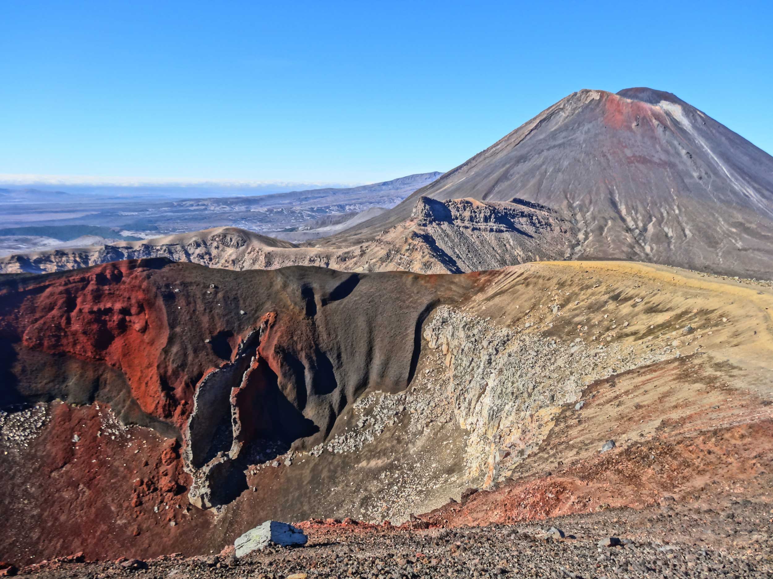
The Red Crater is 1,886 m heigh
This is where you’ll get a view of the amazing Emerald Lakes, as well as the blue lake, which is officially called Te Wai-Wahkaata-o-teRangihiroa. The colors are so spectacular thanks to the white limestone deposits on the lake bed, reflecting the sunlight, similar to that of Kaindy lake in Kazakhstan. You’ll want to spend some time at the lakes – here’s where you can literally test the waters by dipping a toe. Swimming is not permitted, not only because the water is so cold. It’s highly acidic and emits a not-so-pleasant smell of sulfur.Thermal steam can be seen escaping from the rocks nearby.
The Descent
Once you start to descend – this is the most treacherous part of the trail, so take your time – you may want to stop for a leisurely lunch at the Ketetahi Shelter. Here, there are toilet facilities, although there are nine long drop toilets scattered throughout the trail. Be sure to pack out your rubbish, as there are no bins anywhere on the trail.
After lunch, it’s another couple hours of easy decline, past steam vents and more epic vistas that help you see why the land holds such value to the native Maori peoples. Of course, you’ll want to take plenty of pictures along the way for this once-in-a-lifetime hike. In the summer, a clear view can extend for miles. You won’t see a lot of wildlife on the trail, since the harsh lava flow and fires destroy the environment. You may see a wild bird, known as a pipit. But don’t worry – the otherworldly views more than make up for it.
The trail ends at the Ketetahi Shelter. Your shuttle bus will be waiting for you back home for a warm shower, a big meal and plenty of smiles. As Hiking the Tongariro Crossing is undeniably one of the best walks in the world.